Show them this:Still waiting for this citation, OIM, by the way. Having trouble finding it?
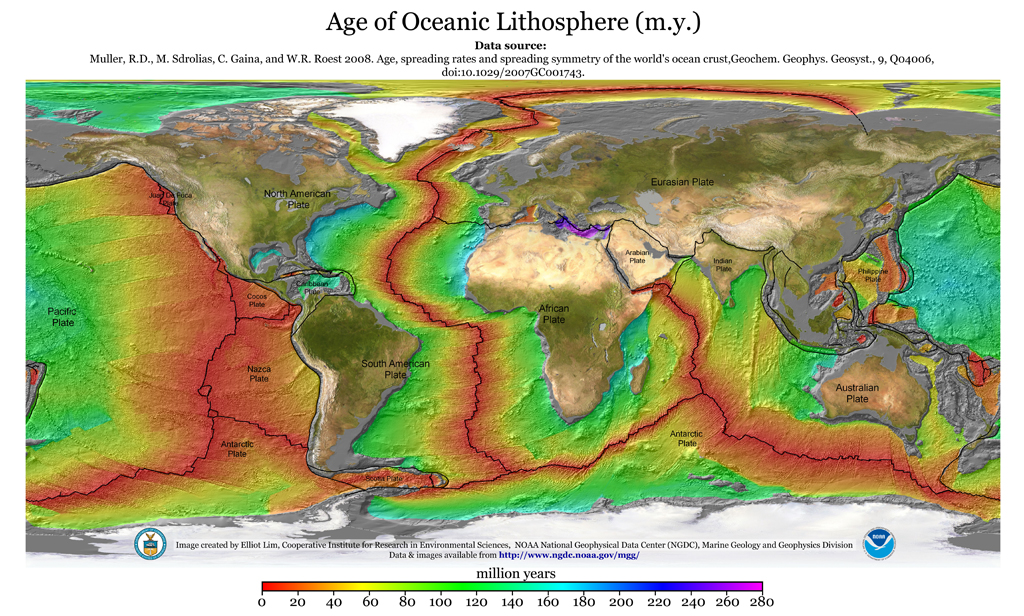
No citation required.

Show them this:Still waiting for this citation, OIM, by the way. Having trouble finding it?
In order to maintain Earth’s current diameter, subduction MUST remove older Pacific Ocean seafloor at a rate equal to ALL new seafloor area added anywhere on the planet—not just the small ~25-40 mm/yr (~1 to 1-1/2 in/yr) of new seafloor added annually along the Atlantic Ocean midocean ridge. The total new seafloor growth, both E-W and N-S, along the ~65,000 kilometers of midocean ridges undoubtedly exceeds ~300 mm/yr (~12 in/yr), and ALL of it must be vectored into the Pacific Ocean basin, the only area on the planet where subduction is believed to occur.
There are other reasons to doubt the validity of subduction. One is the illogical question of why the East Pacific Rise (EPR) should generate ~80 to ~160 mm/yr (~3-1/4 to ~6-1/2 in/yr) of new ocean seafloor—right in the middle of the supposed subduction area, and simultaneously subduct a greater amount elsewhere around its perimeter, leaves one puzzled. This EPR growth is four times greater than seafloor growth anywhere else on the planet and this large amount of new oceanic seafloor does not appear to be accounted for in the VLBI measurements. Where are measurements showing the Pacific Ocean basin DECREASING IN WIDTH?
Also unaccounted for are the vast amounts of new N-S seafloor being added circum-Antarctica that are causing Antarctica to INCREASE IN TOTAL SURFACE AREA AND EXPAND RADIALLY OUTWARD FROM THE PLANET’S CENTER.
This raises the pivotal questions of HOW and WHERE subduction could be occurring because there is NO PHYSICAL EVIDENCE of seamounts or soft sedimentary debris filling the deep ocean trenches or piled up on North or South American shores, semi-liquid debris that would easily have been scraped off the top of any subducting ocean floor.
The Pacific Rim of Fire, the supposed subduction area, suffers frequent earthquakes, but Benioff zones and seismic tomography that scientists point to when trying to justify subduction, only APPEAR to support subduction because they merely provide epicenter depths of earthquakes without providing the direction or extent of movement.
The only way subductionists can PROVE SUBDUCTION is to demonstrate that the Pacific Ocean basin is actually being REDUCED IN SIZE, and that offshore islands or seamounts are rapidly moving closer to shore or are descending into the deep ocean trenches. The simplest solution would be direct trans-Pacific measurements of the changing distances between fixed points on each of the five Pacific continents and Alaska. (Use of satellite measurements (VLBI, LAGEO, GPS) should be avoided because the global grid system of latitude and longitude has itself changed by increased distances between parallels and meridions.)
However, there is no need to go to all this trouble. Since it has been shown earlier that the planet is obviously expanding there is no comparable problem, either physical or mathematical (except for the expanded global grid system). Midocean ridges are the enabling mechanism of global expansion, acting like cranial sutures that permit the human skull to grow to maturity. The midocean ridges simply add new basaltic seafloor from core magma that increases Earth’s total surface area, diameter and circumference, and, like Antarctica, EXPANDS ALL SURFACE AREAS RADIALLY OUTWARD FROM THE CENTER OF THE PLANET!
Expansion poses no geophysical problems--the planet just keeps on growing and expanding, wherever and in whatever form it occurs, but the annual increase in diameter (~5-10 cm/yr or ~2-4 in/yr) is very small and difficult to measure.
Subduction, on the other hand, is purely hypothetical because it is based on a fundamental assumption that the planet has always been the same size since it was formed 4.5-4.6 billion years ago; something almost impossible to prove. This philosophical assumption requires that any addition of surface area to one part of the planet would require an equal compensatory loss in some other region of the planet. Maintaining a constant diameter, however, raises a number of troubling questions about the mechanics of subduction:
a. Not generally realized is that subduction, at a minimum, would require the Pacific basin to decrease in width by at least the ~2-4 cm/yr increase in width of the Atlantic basin in order to maintain Earth at a constant diameter and permit the entire Pacific Ocean basin to be swallowed! But, for subduction to be valid, another ~8-16 cm/yr of East Pacific Rise (EPR) growth (the greatest rate of new seafloor growth on the planet [Fig. 2]) also must be swallowed, for a total minimum subduction rate of ~10-20 cm/yr (~4-8 in/yr).
b. And to the above totals one must add an amount equal to additional seafloor growth along thousands of kilometers of midocean ridges in the Indian Ocean and around Antarctica. The Indian Ocean, which has opened even wider than the Atlantic, also has no evidence of subduction within its confines. How can worldwide seafloor growth in oceans outside the Pacific be vectored smoothly into the Pacific basin where the EPR is generating a prodigious volume of new seafloor in the middle of the Pacific subduction area?
c. A major flaw in subduction dogma is the very young age of the oldest Pacific Ocean sediments ever found in the Pacific basin. These sediments were cored on Ocean Drilling Program (ODP) Leg 129 at Site 801B (18° 38.52´N, 156° 21.582´E, Central Pigafetta Basin, just east of the Mariana Trench) and were found to be only ~169 Ma (Middle Jurassic) in age; roughly equal to the oldest sediments found in the Atlantic Ocean.
d. Using these ODP data and extrapolations from magnetic anomaly lineations (isochrons) in the same area, Nakanishi, et al, arrived at a slightly older age of ~195 Ma, postulating “the shape of the early Pacific plate was a rough triangle” covering an area of 0.04x10[6] km² at ~190 Ma, 0.6x10[6] km² at ~180 Ma, and 3x10[6] km² at ~170 Ma. The Pacific plate is now estimated to cover an area of 108x10[6] km²—which means that the entire Pacific plate has been generated within the last ~195 Ma, thereby constraining the age of the Pacific basin to be no more than ~200-205 Ma.
e. Proponents of subduction may argue that sediment ages less than ~200 Ma supports their contention that all the older Pacific seafloor has been subducted since the Atlantic basin first opened approximately ~160-175 Ma, and therefore none of the original Panthalassan seafloor can be found today. But this is only an inferred assumption and valid only if subduction has really existed. This is now a moot point because the evidence shown in Heezen and Tharp’s map shows that Panthalassa (Wegener's eo-Pacific Ocean) never existed.
f. If subduction were actually occurring to offset worldwide seafloor growth, there should be constant and sustained seismic activity reflecting disappearance of older seafloor at the same rate new seafloor is being generated. There is indeed a great deal of earthquake activity throughout the Ring of Fire, but it is not equally distributed around the Pacific Ocean perimeter commensurate with the constancy of new seafloor growth that must be vectored in from oceanic areas outside the Pacific basin.
g. There is no empirical proof that Pacific perimeter earthquakes are caused by subduction; this is inferred and purely hypothetical. There are more logical explanations such as crustal adjustments due to relaxed curvature and flattening of the Earth's crust as a consequence of expansion in diameter. Earthquakes, though powerful, are merely secondary effects of planetary expansion, not primary geophysical actions with independent motive power.
h. Subduction fails to explain a satisfactory causative mechanism able to force thin ocean floors only 10 km thick to dive beneath thick continental shields 25-40 km thick without leaving behind some physical evidence. There is no evidence of ocean floors and seamounts diving into the deep ocean trenches (the trenches show little or no sedimentation, and no toppled seamounts). As noted by Roger Revelle in 1955, material recovered from even the deepest trenches “resemble in many ways deposits laid down in shallow water.”
i. This exposes a related problem--the missing soft sediments that should have been scraped off the ocean floor when descending beneath a rigid continental shield over a period of two hundred million years. These soft sediments are an unconsolidated top layer of ocean floor ~10 meters thick. Massive amounts of sediments should be piled up against continental shores, or in the deep ocean trenches off the eastern coasts of Asia and Australia, the western coasts of North and South America, or in the Aleutian Trench. The sediments just aren't there; the ocean trenches are relatively free of sediments and there are no mountains of soft sediments piled up against any Pacific shore.
Show them this:
No citation required.
See post above.No - you stated that the Pacific Basin is growing. Where's the citation? A map showing age of the lithosphere is not a citation to demonstrate that the Pacific Basin is growing.
See post above.
The ocean floors are simultaneoulsy growing (at the mid-ocean ridges) and shrinking (at subduction zones). Why do you find this so difficult to understand/accept. There is nothing magical about it and nothing that defies the laws of physics. Which specific law of physics does plate tectonics defy?The ocean floors are growing. They are not magic conveyor belts that defy the laws of physics.
.
There is no unambiguous evidence for most things, but the weight of the evidence points clearly to convection and recirculation. Herndon is in a very small minority with his contrary view. Stop trying to present it as the acceptable view. You are fucking up a good debate with your intransigent stupidity and incessant trolling."To date however, there is no direct unambiguous evidence that mantle convection and/or mantle circulation actually takes place; in fact, there is some evidence to the contrary. Moreover, there is no evidence that oceanic basalt can be repeatedly recycled through the mantle without being substantially and irreversibly changed. Yet, mantle convection/circulation and basalt recycling are fundamental necessities for the validity of plate tectonics. Furthermore, plate tectonics theory does not provide an energy source for geodynamic activity." -- J. Marvin Herndon, geophysicist, 2005
I didn't call you a dickhead. I gave you fair warning that if you continue to act like one people will come to believe you are one."Calling someone a dickhead is not a logical or scientific argument but no one expects that from plate tectonics fundamentalists so go right ahead.
I'll make you a deal, you show me the peer reviewed paper that demonstrates the Pacific is shrinking and then I'll show you one that demonstrates it is growing.I said from reputable sources (not EE sites).
It is impossible for granite or basalt to be subducted into the mantle because peridotite is more dense than granite or basalt.Which specific law of physics does plate tectonics defy?[/COLOR]
I'll make you a deal, you show me the peer reviewed paper that demonstrates the Pacific is shrinking and then I'll show you one that demonstrates it is growing.
The Cenozoic decrease in productivity is largely reflected in the Pacific (∼25%) and Indian (∼13%) basins
The decrease in
seafloor consumption rates is primarily a Pacific
phenomenon, which is expected given the area decrease
of the Pacific basin during the Cenozoic.
"Over twelve years of laser ranging to the LAGEOS spacecraft have enabled the motions of the Earth's crust to be determined at approximately twenty laser tracking sites around the world. ...The relative motion of Hawaii and Arequipa is 80±3 mm/yr from our solution compared to the geologically predicted 66 mm/yr." (Smith et al, 1990).
So if Hawaii and Arequipa are moving away from eachother at 80±3 mm/yr, then the Nazca Plate cannot possibly be subducting. Therefore the Pacific is growing.
Furthermore, +65.33 mm/yr increasing width between Yaragadee Australia and Arequipa Peru (Smith et al., 1993). Therefore the Pacific is growing.
The 1990 paper is titled "The determination of present-day tectonic motions from laser ranging to LAGEOS." The 1993 paper is titled, "SLR Results from LAGEOS." However the exact paper is irrelevant since the scientific literature contains countless papers purporting to prove subduction, but which unwittingly include several measurements that show the Pacific Ocean basin to be increasing in width--not decreasing in width as required by subduction.Few things here:
1 - you need to supply a full reference. Especially when the first author is Smith! I went to the LAGEOS publications page and did not find any papers authored by Smith in 1993. There were also 5 or 6 authored by Smith in 1990 - which one is it?
Are you aware that the Nazca Plate is in between Hawaii and Peru?2 - The Hawaii/Arequipa motion is to be expected - there's a spreading ridge right between them! If you look at the plate motions (http://sideshow.jpl.nasa.gov/mbh/series.html)
it's very clear why these two places are moving apart. Additionally, Peru isn't on the Nazca plate - it's on the South American plate. The Nazca plate can still be subducting, whilst Hawaii and South America move apart. (And the above motions maps shows this.)
Keep telling yourself that.In short this does not prove the Pacific Basin is getting bigger.
Keep telling yourself that.3 - The Australia/Peru motion is also explained by the plate motion map. Again - it doesn't prove the Pacific Basin is getting bigger. Looking at the motion map it's clear that it is getting smaller.
Even though they do?4 - Measurements over the last 20 years cannot show a long term increase in the size of the Pacific Basin.
You don't believe the measurements for the past 20 years but you believe the speculation of what happened 10 million years ago? Why is that?If the Earth is expanding then you need long term data - 10's of millions of years.
Of course only plate tectonics can show fake made up make believe continents that didn't exist millions of years ago. No other tectonic theory has people gullible and stupid enough to believe in Mu or Pangea.Only plate tectonic reconstructions can show this.
The 1990 paper is titled "The determination of present-day tectonic motions from laser ranging to LAGEOS." The 1993 paper is titled, "SLR Results from LAGEOS." However the exact paper is irrelevant since the scientific literature contains countless papers purporting to prove subduction, but which unwittingly include several measurements that show the Pacific Ocean basin to be increasing in width--not decreasing in width as required by subduction.
Are you aware that the Nazca Plate is in between Hawaii and Peru?
Keep telling yourself that.
Keep telling yourself that.
Even though they do?
You don't believe the measurements for the past 20 years but you believe the speculation of what happened 10 million years ago? Why is that?
Of course only plate tectonics can show fake made up make believe continents that didn't exist millions of years ago. No other tectonic theory has people gullible and stupid enough to believe in Mu or Pangea.
I thought James kicked your ass on this crap earlier ? You are still at it ?
Really ? In my recollection James pretty much proved you were wrong. So I don't see how you can justify continuing to spout this nonsense..If you don't have anything intelligent or relevant to say and you don't want to contribute to the thread or conversation then stay out.
The forum already has too many people who focus all their energy researching new ad hominem fallacies but who have no logical or scientific arguments.
The 1990 paper is titled "The determination of present-day tectonic motions from laser ranging to LAGEOS." The 1993 paper is titled, "SLR Results from LAGEOS." However the exact paper is irrelevant since the scientific literature contains countless papers purporting to prove subduction, but which unwittingly include several measurements that show the Pacific Ocean basin to be increasing in width--not decreasing in width as required by subduction.
Are you aware that the Nazca Plate is in between Hawaii and Peru?
Keep telling yourself that.
You don't believe the measurements for the past 20 years but you believe the speculation of what happened 10 million years ago? Why is that?
Of course only plate tectonics can show fake made up make believe continents that didn't exist millions of years ago. No other tectonic theory has people gullible and stupid enough to believe in Mu or Pangea.
That's not a law of physics. That is a poorly formulated opinion.It is impossible for granite or basalt to be subducted into the mantle because peridotite is more dense than granite or basalt.
This is excellent advice. When can we expect you take it?If you don't have anything intelligent or relevant to say and you don't want to contribute to the thread or conversation then stay out..